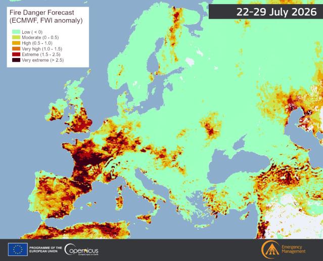
We are starting the week’s live blog slightly later this week’s where our attention is geared towards southern Europe as extensive and large amount of wildfires are breaking out as a result of months of extreme heat and dry conditions.
We will track the active and emerging wildfires and report on the fatalities and overall impacts as data comes in, and will look at how governments are responding to the wildfire and crisis combined with viewpoints from experts.
It is updated dayly for the remainder of the week and into early next week.
Extensive and large amount of wildfires breaks out across southern Europe
Extreme heat to return to the European continent
Latest
Saturday 25th of July 2026
12:00 GMT
France: Not even into August yet, and 2026 have already become the worst wildfire year yet on record.
2026 has surpassed 2022 in terms of most land-area burned. Data released by the EU’s European Forest Fire Information System (Effis), 69,473 hectares of land have burned in the country since the beginning of 2026. In 2022 66,337 hectares. Effis have been collecting burned land-area since 2006.
Friday 24th of July 2026
16:10 GMT
Active wildfires: The below tracker shows the current active wildfires in Europe:
🇵🇹 Portugal
🟠 Local active fires
Northern Portugal
Very High
🇪🇸 Spain
🔴 National wildfire emergency
Ávila, Madrid region, Castilla y León
Very Extreme
🇫🇷 France
🔴 Multiple major wildfires
Gironde (Cap Ferret), Landes (Biscarrosse)
Very Extreme
🇮🇹 Italy
🟠 Multiple active fires
Sicily, Sardinia
Very High
🇬🇷 Greece
🟠 Local active fires
Attica, Central Greece
Extreme
🇹🇷 Türkiye
🟠 Multiple fires
Western Türkiye, İzmir Province
Very High
🇭🇷 Croatia
🟡 Isolated incidents
Adriatic coast
High
🇲🇪 Montenegro
🟡 Local fires
Inland forests
High
🇧🇦 Bosnia & Herzegovina
🟡 Scattered incidents
Central mountains
High
🇷🇸 Serbia
🟡 Small outbreaks
Southern Serbia
High
🇦🇱 Albania
🟠 Several active fires
Southern mountain regions
High
🇲🇰 North Macedonia
🟠 Active
Central forests
High
🇷🇴 Romania
🟡 Local woodland fires
Carpathian Mountains
Moderate
🇧🇬 Bulgaria
🟠 Several fires
Southern Bulgaria
High
🇸🇮 Slovenia
🟢 None significant
—
Moderate
🇦🇹 Austria
🟢 Very few
Alpine forests
Moderate
🇩🇪 Germany
🟡 Local woodland fires
Brandenburg, Saxony
Moderate
🇵🇱 Poland
🟡 Isolated fires
Eastern forests
Moderate
🇸🇪 Sweden
🟡 Small forest fires
Central Sweden
Elevated
🇫🇮 Finland
🟡 Local forest fires
Northern Finland
Elevated
🇳🇴 Norway
🟢 Minimal
—
Low
🇬🇧 United Kingdom
🟠 Multiple heath and moorland fires
Cairngorms National Park (Scotland), Southern England
High
🇮🇪 Ireland
🟡 Local moorland fires
Wicklow Mountains
Elevated
Earlier updates
15:55 GMT
Wildfire evacuations: Thousands of people have been forced to evacuate from the south-western part of France as wildfire conditions have been worsening alongside the Cap Ferret peninsula on the Atlantic Coast.
More than 10,000 hectares are impacted by the the two largest wildfires in the region.
Discover more from A greener life, a greener world
Subscribe to get the latest posts sent to your email.