


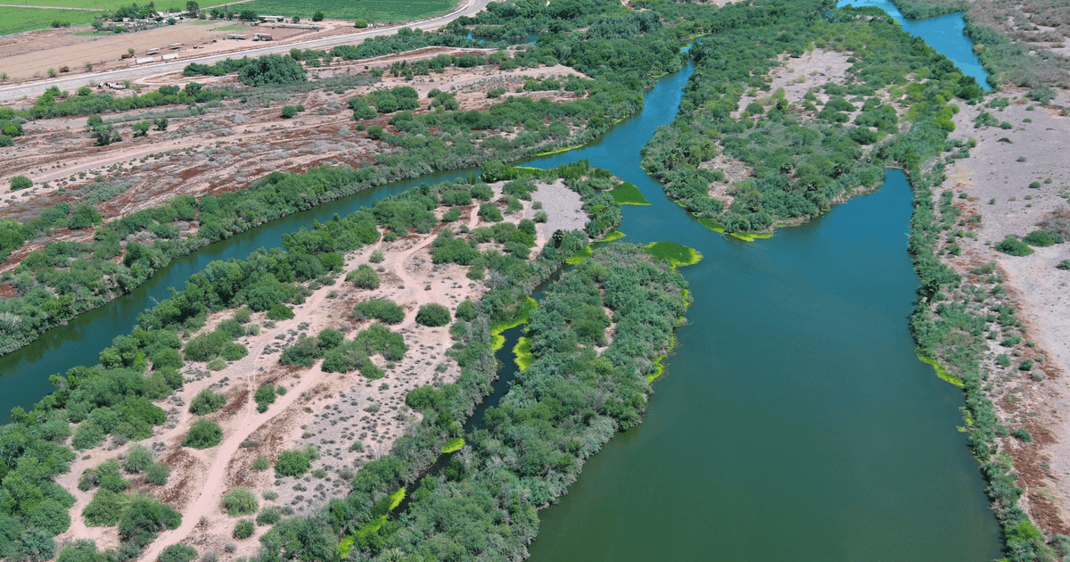
Significant changes have occurred in the ecosystems of the Lower Gila River (the river stretch from the City of Phoenix’s Tres Rios Wetlands to Gillespie Dam south of Arlington), due to historic land and water management practices (such as dams and diversion upstream) combined with a hotter and drier climate.
These changes have contributed to the proliferation of invasive plants—like salt cedar (also known as tamarisk)—crowding out native plants, decreasing the water quality and quantity, reducing recreational access to the river, and creating choke points that can cause damaging floods with high river flows. The expansion of salt cedar also poses a heightened fire risk because the species burns hotter and quicker than native desert plants, fueling fires that burn more intensely.
This 36-mile stretch of the Lower Gila River has seen its share of wildfires over the years, with the recent Hazen Fire (May 2026) burning nearly1,200 acres in the Gila River bottom near Buckeye.
Audubon Southwest and partners are building upon decades of work in the area and coming together as the Lower Gila River Collaborative (LGRC) to revitalize the river by advancing strategic habitat restoration, reducing flood and fire risk, improving recreational access, and boosting economic opportunities in the corridor.
To advance the conversation, Audubon hosted the Lower Gila River Forum at the Nina Mason Pulliam Rio Salado Audubon Center. Participants discussed land and water issues in the Lower Gila River, including funding needs, barriers to implementing more projects, and on-the-ground restoration work.
U.S. Rep. Juan Ciscomani, (R-Ariz.) provided virtual opening remarks. The event brought together state leaders, city council members, Tribal representatives, water agencies, and congressional staff from the offices of U.S. Reps. Greg Stanton (D-Ariz.) and Yassamin Ansari (D-Ariz.), and U.S. Sens. Mark Kelly (D-Ariz.) and Ruben Gallego (D-Ariz.).
Sine Kerr, Farm Services Agency State Executive Director for Arizona, shared a legacy perspective from her time as an Arizona State Senator where her legislative accomplishments included the 2022 historic investments in Arizona’s water future by expanding the Water Infrastructure Finance Authority of Arizona, as well as securing $5 million for the Gila River Nonnative Vegetation Species Eradication Fund. This investment allowed the Arizona Department of Forestry and Fire Management to remove salt cedar and establish native plants at project sites, creating a more resilient landscape.
Dr. David DeJong spoke on the Gila River Indian Community’s long-term vision for its water future and the innovative habitat restoration and groundwater recharge facilities the community has built to revitalize the Gila River.
Panelists from the City of Goodyear, Buckeye Water Conservation and Drainage District, and CalPortland offered perspectives from a municipal, agricultural, and mining point of view.
Another panel—featuring the City of Phoenix, Arizona State University’s Rio Reimagined initiative, the Arizona Game and Fish Department, and the Arizona Department of Forestry and Fire Management—explored conservation, recreation, and funding opportunities and showcased the work of the Lower Gila River Collaborative.
And back in March of 2026, the Arizona Department of Forestry and Fire Management hosted State Sen. Tim Dunn (R-Ariz.) and other stakeholders on a tour of their Lower Gila River Initiative project sites to see what investing in this type of restoration work to remove salt cedar and reestablish native plants looks like on the ground. One of the sites visited, near Highway 85, proved to serve as a fire break in the Hazen Fire, protecting the bridge infrastructure while improving the resilience of the landscape. This restored site stands out in the aftermath of the fire, as flames skirted around the area.
In 2025, the Lower Gila River Collaborative partners removed 784 acres of invasive plants, planted 645 native species, and enhanced more than 740 acres of riverside habitat, in addition to outreach efforts with landowners and the local community.
The work is not over once the salt cedar is removed and native species are planted. Restoration sites must be monitored and maintained to prevent salt cedar from returning and to measure progress on the health of the native plantings.
To measure progress, in 2025, Audubon and the Lower Gila River Collaborative partners began a drone vegetation monitoring initiative in the river corridor. Audubon Southwest’s licensed drone pilots (Elija Flores and Tucker Davidson) planned and executed flights over project sites with our multispectral drone. “Multispectral” means the drone is equipped with single-wavelength cameras that capture specific wavelengths of light, like Near Infrared, which is invisible to the human eye.
After the drone flights, the data is processed using specialized Geographic Information System (GIS) tools to produce maps and models that can be analyzed to determine a variety of elements from plant type and health, soil conditions, and much more. By performing these drone flights and analyses on a biannual schedule, we are creating a library of snapshots in time and gathering takeaways to inform and prioritize future restoration work.
And down at the state Capitol, legislators are crafting the state budget for the next fiscal year, which begins July 1, 2026. This legislative session, Senator Dunn introduced Senate Bill 1677, which would allocate $3 million to the Arizona Department of Forestry and Fire Management to continue their work to reduce flood and fire risk by strategically removing salt cedar and reestablishing native plants, restoring habitat along the Lower Gila River west of Phoenix and along the confluence of the Gila and Colorado Rivers, near Yuma. This bill unanimously passed the House Natural Resources, Energy, and Water Committee on March 24. Now, it must be incorporated into the state budget to become a reality.
There is much work to be done in this river corridor, work that could not be accomplished without the ongoing partnership of diverse stakeholders, to improve the outlook of the Lower Gila River. Audubon is especially grateful to have received a WaterSMART Cooperative Watershed Management Program grant from the U.S. Bureau of Reclamation to strengthen the Lower Gila River Collaborative and carry out its strategic action plan.
Be sure to sign up for our Western Water Action Network to receive alerts about opportunities to weigh in on water management decisions—like investing in Arizona’s lands and waters in the state budget—that will shape the future of Western rivers, lakes, and the birds, wildlife and people that depend on them.
The Lower Gila River Collaborative (LGRC) is a voluntary partnership of more than 30 state agencies, non-governmental organizations, Tribes, and recreation and agricultural water users, including Gila River Indian Community; cities of Avondale, Buckeye, Goodyear, and Phoenix; Maricopa County Parks and Recreation Department; Flood Control District of Maricopa County; Arizona Department of Game and Fish; Arizona Department of Forestry and Fire Management; and U.S. Fish and Wildlife Service.


